- Departments
- Residents
- Business
- Visitors
Evolution of the Downtown District
Return to Take the Historic Downtown Chehalis Walking Tour
Between 1850 and 1950, Chehalis developed from a rural hamlet with a handful of pioneer homesteads into an agricultural and wood processing center of over 5,600 residents. Within this century of growth, the city center has migrated twice. The location of the downtown district proved a source of local contention, illustrating how private boosterism played a powerful planning function in early community development.
The First City Center: Western Main Street
Chehalis’s first commercial district and civic center was located along Main Street, west of the tracks of the Northern Pacific Railroad. There were two reasons for the early concentration of activity in this area. First was its proximity to the railroad, the transportation and communication link with distant markets and political capitals. Second was the availability of real estate. As early as 1875, Eliza Barrett platted three blocks of Main Street, west of the railroad tracks, and here the town began to grow.
The first glimmering of an urban core was the collection of buildings and businesses that sprang up in the 1870s near the warehouse erected as the settlement’s first railroad station. The small warehouse was followed by a general store established by a merchant from a neighboring community, and by the end of the decade the warehouse itself had been enlarged into a full-scale meat packing plant. Construction of two civic buildings in the mid-1870s confirmed the municipal significance of western Main Street. When Chehalis was designated the county seat, the courthouse was erected on an acre west of the tracks and a block north of Main Street. Two years
later, in 1876, the first schoolhouse was built near the courthouse at State and Center streets.
The Second City Center: Main Street & Chehalis Avenue
As the town developed, commercial activity spread east along Main Street toward its intersection with Chehalis Avenue. This area became the second city center in the 1880s. Eliza Barrett played a crucial role as an urban planner by releasing five parcels for development between 1881 and 1883. One of her many critics, who believed she had not been sufficiently interested in schemes to develop her land, was pleased with the platting. “Parties holding property in the past with a death grip have been gradually letting go,” he informed the readers of the Lewis County Bee in 1884.
Toward the end of the decade, Eliza Barrett moved to solidify the increasing importance of the intersection of Main and Chehalis as the new city center. Her construction of two significant structures on diagonal corners -- the Tynan Opera House and the Barrett Block, a large brick building that came to house a bank and the Barrett Hotel -- seemed to confirm that Chehalis and Main would be the cultural and commercial heart of the growing city.
But two fires in 1892 destroyed most of the wooden buildings in this part of town, as well as its prospects as the city center. The first fire in March consumed a block of business buildings. A second fire on May 22, less than two months later, was even more devastating, leveling about thirty buildings in four blocks. The blaze spread so rapidly that “little was saved by the residents and businessmen in the entire district,” according to The Chehalis Nugget, reporting on the day of the inferno. In the newspaper’s opinion, both fires were set deliberately. After the March fire a number of citizens in the burned-out district apparently suspected arson, but the second fire, The Nugget stated flatly, “was beyond doubt started by an incendiary.”
Although redevelopment was considered for Main Street, the post-fire building boom occurred six blocks to the north on Market Boulevard, much resented by the merchants and residents of the former downtown. The two suspicious fires encouraged the development of a third city center and caused the value of Eliza Barrett’s real estate to decrease greatly in value.
The Third City Center: Market and Boistfort
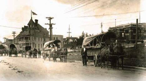
The dramatic shift of the central business district from Main Street to Market Boulevard in the 1890s is often attributed to the two great fires of 1892. Actually, the fires did not inaugurate the migration of the city center so much as they coincided with it. Even before the fires, some of the city’s leading citizens were backing a competing business district centered at the intersection of Market and Boistfort Street. The First National Bank building, erected in 1889, was the first important commercial structure at the location, and other buildings quickly followed the example of the community’s leading bank. The Chehalis Improvement Company constructed two other buildings, the Improvement Block (1891) and the Columbus Block (1892), on opposite corners at Market and Boistfort. A first-class hotel went up next. Between 1890 and 1894, the Chehalis Land & Timber Company, with financing from the First National Bank, constructed the St. Helens Hotel a block away from the newly pivotal intersection. In short, three years before the calamitous fires, banking and real estate interests were already embarked on a major development project outside the traditional business corridor of Main Street.
The motives behind this effort to reshape the commercial geography of Chehalis seemed clear to the local journalist who characterized the activities of the Chehalis Improvement Company as an attempt by prominent citizens to insure “a solid appearance for the town as well as a profitable investment for themselves.” But the undertaking may have also represented an attempt by civic boosters to reduce Eliza Barrett’s future role in urban growth by establishing a downtown outside her control. New commercial buildings continued to be erected on both Chehalis Avenue and Main Street, but the civic prominence of Market Boulevard was unchallenged for sixty years after the 1890s. Not until the 1950s did the business district begin to shift another time, to the shopping mall complex (now Sunbird Shopping Center) on National Avenue.
The 19th-century struggle over the location of the city center pitted the ambitious and self-interested calculations of some of the community’s most prominent citizens against the somewhat less materialistic concerns of an early, and largely forgotten, female town planner. More generally, the evolution of the downtown district illustrated how the process of community development was shaped by competing private visions of its urban future.